المشروع
المجتمع
الأخبار
تطبيقي
خرائطي
خرائط ساوث بلينفيلد (نيوجيرسي)
بحث متقدم
الكل
خاص
المفضلة
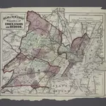
Atlas of New Jersey : Counties of Essex, Union, and Hudson.
1873
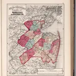
Atlas of New Jersey, Counties of Middlesex and Monmouth.
1873|Hopkins, G.M.
1:253 440
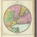
Map of the Country Twenty Five Miles Round The City Of New-York.
1835|Burr, David H., 1803-1875
1:211 200
Map of the counties of New York, Queens, Kings, and Richmond.
1829
Map of the counties of New York, Queens, Kings, and Richmond.
1841
Map of the counties of New York, Queens, Kings, and Richmond.
1829
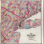
New York & vicinity.
1868|Beers, F. W. (Frederick W.)
1:253 440
1600
1650
1700
1750
1800
1850
1900
1950
2000
التاريخ
الخرائط القديمة لـ ساوث بلينفيلد (نيوجيرسي)
اكتشف ماضي ساوث بلينفيلد (نيوجيرسي) على الخرائط التاريخية
الخرائط القديمة لـ ساوث بلينفيلد (نيوجيرسي)
اكتشف ماضي ساوث بلينفيلد (نيوجيرسي) على الخرائط التاريخية
استكشاف الخرائط
اكتشف التاريخ
المنطقة الأم
مقاطعة ميدلسكس (نيو جيرسي)
الأماكن ذات الصلة
© MapTiler
© OpenStreetMap
 1873
1873
 1873|Hopkins, G.M.1:253 440
 1835|Burr, David H., 1803-18751:211 200
 1829
1829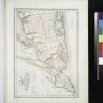 1841
1841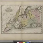 1829
1829
 1868|Beers, F. W. (Frederick W.)1:253 440